TheTrams.co.uk - trams and light rail in the UK
The section of line in the city centre (Victoria/Piccadilly–G-Mex) is described in the City page.
The Bury line was part of the original, Phase One, network. The line runs along reserved track, from Victoria to Bury, a town on the northern edge of Greater Manchester. The line uses the former Lancashire and Yorkshire Railway route, which was transferred from British Rail in 1992. This line was opened in 1879, and electrified in 1916 by a unique 1200Vdc side-contact system, which was still in operation when the line was closed for Metrolink conversion.
Apart from the overhead line equipment, the construction of new platforms at Victoria and the addition of lifts, only cosmetic alteration has taken place, with many of the stops retaining station buildings which date from modernisation work carried out in the 1950s. There has been some additional work in recent years, including the demolition of buildings at some of the stops and the addition of ramps and car parks at a couple of locations.
The line is very different in flavour to the southern half of Phase One, the Altrincham line. There is a mix of inner-city decay, suburban residential areas, mill towns and semi-rural surroundings, with tunnels, cuttings, embankments and viaducts, all giving a constantly-changing view from the trams. There is nothing which matches the flat landscape of the Altrincham line; another difference is that where the Altrincham line is almost entirely suburban in nature, the Bury line is almost inter-urban at its northern end. Yet another contrast is the way that Altrincham line exits the city with a fanfare, leaving the city centre in grand style along the brick arches of the former Central station and the magnificent Castlefields viaducts, while the Bury line slinks away from Victoria along the side of the Irk Valley, partly in tunnel, partly hidden by greenery.
The Manchester Geographical Society website also has this very detailed description of the Bury route (PDF file), with some historical photographs.
[select a stop for pictures]
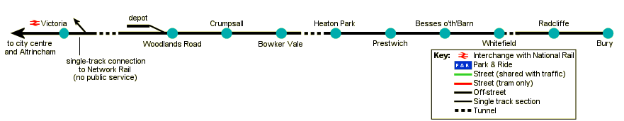
Victoria–Woodlands Road


After leaving Victoria the tramway joins the original L&YR formation, running alongside the main line to Oldham and Rochdale. Cheetham Hill Road crosses rail and tram tracks immediately to the east of the station—at the insistence of British Rail the bases of the bridge supports were encased in concrete to prevent damage to the bridge from a collision by a tram. There is a connection between the Metrolink and National Rail running lines just outside of Victoria, which is for emergency/engineering use only.
Metrolink dives under the main line through Collyhurst Tunnel, and then runs through the Irk valley, which mixes greenery and urban decay, to Queens Road depot. Smedley viaduct carries the line over the river, and over the trackbed of the Manchester Victoria East Junction–Thorpe Bridge Junction line, formerly an alternative route for trains from Victoria to Oldham and Rochdale. There is a link between this route and the Metrolink line, albeit trackless, which could be used as part of the Phase 3 line to Oldham and Rochdale.
There is the possibility of a stop at Queens Road to serve the Cheetham and Collyhurst areas. In the meantime there is a staff halt serving the depot, which is on the west side of the running lines with a connection to the north. A short distance after the depot is Woodlands Road stop.
Woodlands Road–Heaton Park


After Woodlands Road the line continues along the former railway line, mostly in cutting, with a number of high overbridges, through Crumpsall to Bowker Vale. This is the closest stop to the Manchester Transport Museum's Heaton Park Tramway, which runs in summer using, amongst other vehicles, former Manchester Corporation 765, a single-deck tram from 1914. The line then runs through the 695 yard long Heaton Park Tunnel, underneath the biggest municipal park in Europe, to Heaton Park stop at the south-western corner of the park.
Heaton Park–Whitefield


The next stop is Prestwich, then Besses o'th'Barn. Immediately before Besses, the line runs across a concrete beam viaduct below which is Bury New Road and, below that, the M60 motorway. Then comes Whitefield, where the adjacent bus station is to be redeveloped as a Park and Ride site.
Whitefield–Bury


Immediately north of Whitefield is a short tunnel, then the linside scenery undergoes another change as the line enters the Irwell valley and runs on a viaduct through the mill town of Radcliffe. Here there were once junctions with two other important lines: southwards to Manchester via Salford and northwards to Bolton.


The line crosses the river Irwell, just after Hagside Crossing, which is the only level crossing controlled by Metrolink, and then heads for the terminus at Bury, a town on the edge of East Lancashire hill country.
Bury

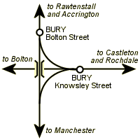
Trains from Manchester Victoria originally ran into Bury Bolton Street station, one of two railway stations in the town, and the line continued up the Irwell valley to Rawtenstall and beyond. The line was closed to passengers beyond Bury in 1972, and in 1980 a short diversion was built to take the electric trains into terminal platforms in the new Bury Interchange, an integrated bus and railway station. Goods trains continued to run on the line north of Bury Bolton street, running across the Interchange tracks on a flat crossing and continuing via Heywood to Castleton on the Manchester–Rochdale line. These services ceased later in 1980, and the line north of Bury was subsequently transferred to the East Lancashire Railway who now run steam train services on the line. There is no connection between the Metrolink tracks and the ELR.
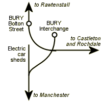
As part of the East Lancashire Railway's extension from Bury to Heywood in the 1990s, the flat crossing outside Bury Interchange was replaced by an overbridge—steam trains now climb up a 1 in 36 gradient (nicknamed the ski jump) to cross the tram tracks.
Railway/Metrolink lines in Bury
Not to scale—some lines omitted for clarity
Original layout of lines in Bury
Layout of lines after 1980
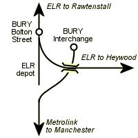
Present-day layout
[copyright statement] [terms & conditions] [trespass & safety policy] [privacy]
TheTrams.co.uk is not associated with any transport operator or authority
All content © Peter Courtenay 2004–2026 except where otherwise stated


Page generated in ≈ 0.0106 seconds