Croydon Tramlink : Routes : Tramlink routes
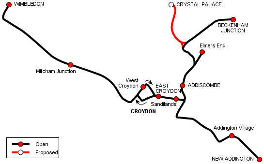
The Tramlink network consists of three main lines (one with a short spur), connected by a one-way loop around Croydon town centre. The three lines run to Wimbledon in the west, Beckenham and Elmers End to the north-east and New Addington to the south-east. Much of the network was converted from main line railway routes, with the remainder using reserved alignments, except for the single-track one-way loop in Croydon town centre and a section of double track between East Croydon and Lebanon Road, which are on street. The network opened in stages in 2000.
Following on from the success of the initial network, a number of proposals have been made for extensions throughout South London. These have included lines to Streatham, Purley, Sutton and Crystal Palace, but only the last of these bears any possibility of becoming reality in the immediate future.
Click for a map of Tramlink in Croydon town centre.
The Tramlink network incorporates some former railway lines. Click for a map showing these routes, the current Tramlink routes and their relationship to other railway lines in the Croydon and Beckenham area.
[copyright statement] [terms & conditions] [trespass & safety policy] [privacy]
TheTrams.co.uk is not associated with any transport operator or authority
All content © Peter Courtenay 2004–2026 except where otherwise stated


Page generated in ≈ 0.0032 seconds