Nottingham Express Transit : Routes : Line Three (Chilwell and Beeston—planned)
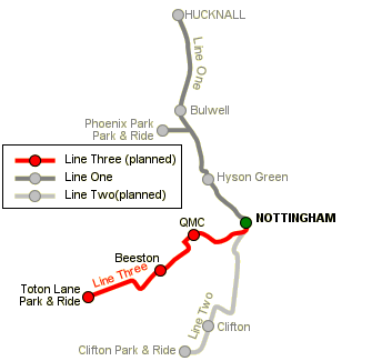
NET's current plans for Line Three involve extending the existing tramway from the terminus at Station Street through The Meadows, then west through the former Royal Ordnance Factory site (ng²), the Queen's Medical Centre, Nottingham University, Beeston town centre and Chilwell to a new Park and Ride site off the A52 at Toton.
[click on a station for pictures]
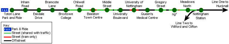
City–ng²
Line Three will follow the same route as Line Two out of Station Street as far as The Meadows. The lines will diverge where Line Two turns left into Sheriffs Way and Queen's Walk, with Line Three continuing along Meadows Way through a stop at Meadows North. The new line will cross the A453 Queen's Drive and entering the ng² development site. This is the former Royal Ordnance Factory. ng² tram stop will be located just after the line has crossed Queen's Drive.
ng²–Nottingham University


Line Three will travel through the ng² site, then across the Kings Meadow nature reserve, joining Lenton Lane just before the bridge over the Nottingham Midland–Beeston railway line. The tramway will run along Lenton Lane, over the Nottingham Canal bridge to a stop at Gregory Street. From here the tram will turn left (south) onto Abbey Street for a short distance, before turning right (west) and reaching a stop at the first floor level of the Queen's Medical Centre, Nottingham's teaching hospital. The tram line will then cross the A52 Clifton Boulevard and enter the campus of Nottingham University. The line will turn left (south) to a tram stop for the University.
Nottingham University–Beeston


After the University tram stop, the line will turn right (west) to join the A6005 University Boulevard, a dual carriageway which runs alongside the University. Just before the roundabout junction with Queen's Road East there will be a stop called University Boulevard, and after this junction the line will travel along Lower Road.
Lower Road is a dead end, at the end of which is Neville Sadler Court, an old peoples' home. For the tram to reach Beeston town centre, a number of flats here will need to be demolished, although alternative flats will be built, which NET say will be better than the existing accomodation.
After Neville Sadler Court, the line will travel down Fletcher Road to Middle Street, where there will be a stop. The line will turn right (northwest) into Styring Street and The Square shopping centre, where some further demolition (of shop units) will be required. Beeston Town Centre stop will be adjacent to the shopping centre.
Beeston–Chilwell–Toton


After Beeston Town Centre stop the line will turn left (southwest) along Chilwell Road as far as Broxtowe College. There will be stops at Chilwell Road (near Park Road) and Broxtowe College. After the college stop the line will turn right (northwest) onto a new reserved route, following the route of a stream (which will be culverted) through residential areas of Chilwell. There will be a stop at Bramcote Lane where the line crosses this road, and there are now also plans for an additional stop where the line crosses Cator Lane. The next stop will be at Eskdale Drive, near to playing fields. The line will run alongside Eskdale Drive, with a penultimate stop at Inham Road, and after crossing Inham Road and running through open fields, the line will terminate at Toton Lane Park and Ride stop. This new Park and Ride site will be close to Junction 25 of the M1, as well as the A52 from Derby and the west. Combined with the Park and Ride sites at Phoenix Park (Line One) and Clifton (Line Two), this will mean there is a Park & Ride site for each of the three motorway junctions which service Nottingham (Junction 24–26 of the M1).
Support for Line Three
BACIT (Beeston & Chilwell Integrated Transport) is an independent pressure group which supports the construction of Line Three via this route.
[copyright statement] [terms & conditions] [trespass & safety policy] [privacy]
TheTrams.co.uk is not associated with any transport operator or authority
All content © Peter Courtenay 2004–2026 except where otherwise stated


Page generated in ≈ 0.0119 seconds